 |
| DATOS ESTRATIGRAFICOS: coordinadas / fecha de inscripción / posición -/-/245
12/08/2005 SECTOR 5/59/51144 DESCRIPCIÓN Costilla de mamífero (fragmento)
Cara interna INSCRIPCIÓN / ELEMENTOS GRÁFICOS: HIIRMOPOLIS, la primera «o» bastante mal trazada.
|
¿Hermopolis? ¿Pero qué hay alli?
Hacemos un viaje a Hermopolis para averiguarlo.
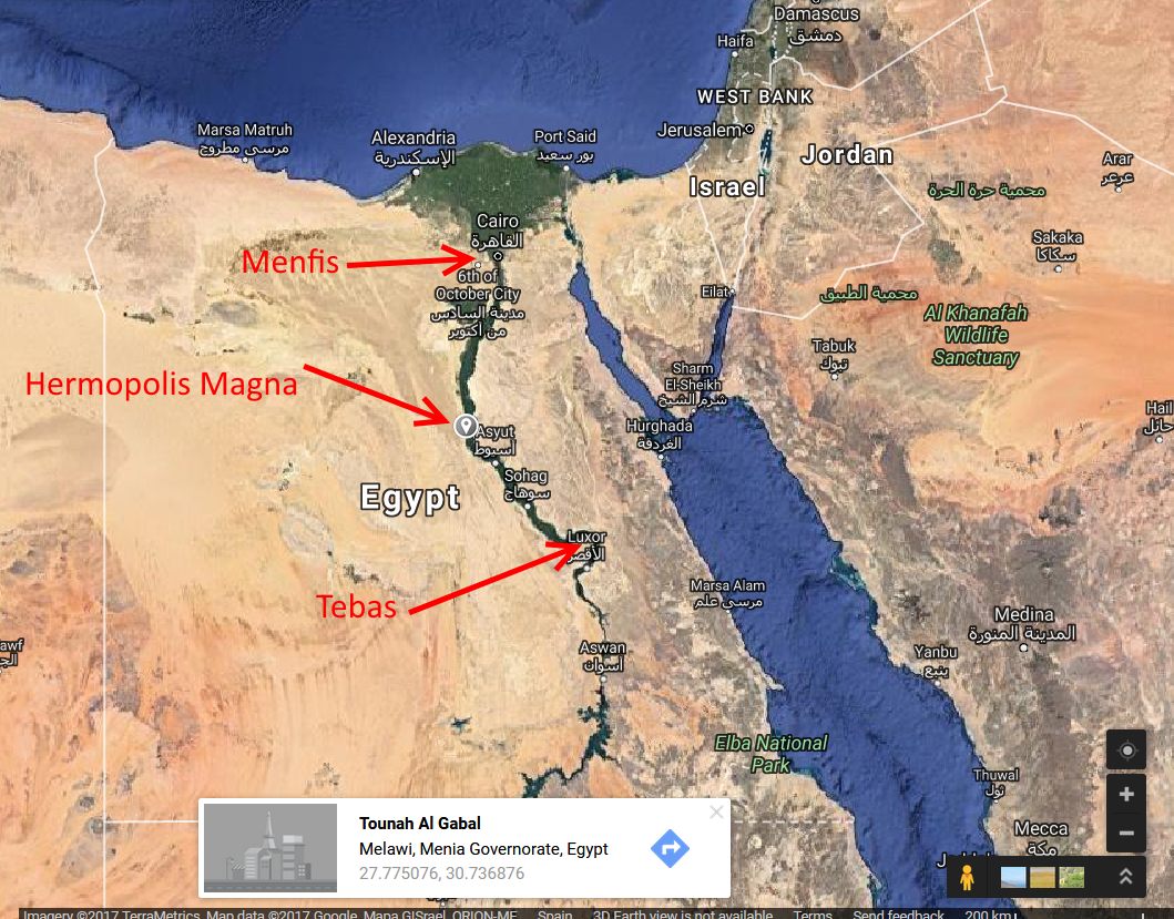
Cogemos como los de siempre un barco y subimos en Nilo hasta medio camino entre los capitales Menfis y Tebas.
Un par de kilómetros en taxi, y ya hemos llegado al pueblo Al Ashmunin (Khemenu en egipcio antiguo). Su mayor esplendor lo encuentra en la época romana bajo el nombre Hermopolis Magna.
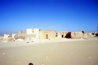
Algo fuera del pueblo encontramos las ruinas de la vieja ciudad con un templo importante del dios Toth, una basílica cristiana, restos coptos. Esta ciudad era un centro importante del cristianismo a partir del siglo III y de la iglesia copta, como sede episcopal. Siempre ha mantenido una relación especial con la iglesia de Roma. Algunas fuentes cristianas lo relaciones con el refugio en Egipto de la familia de Jesús escapando de Herodóto – según Wikipedia (¿?)
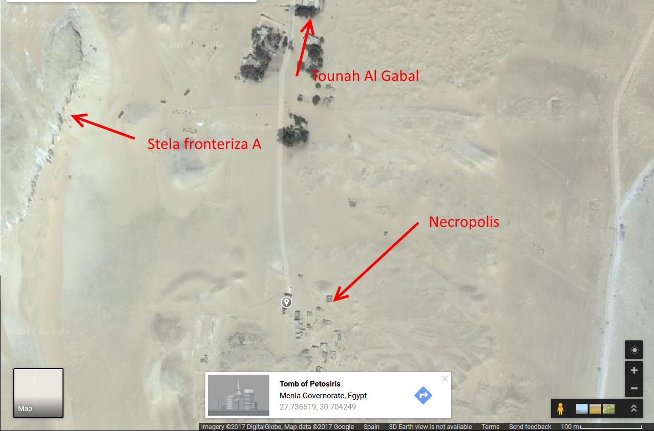
Pero en realidad mi plan es llevar os al desierto unos 10 kilómetros al suroeste, al yacimiento de Tuna el-Gabel (en inglés, en castellano Tuna el -Jabel). Mejor alquilamos un coche.

Primero nos dirigimos al pueblo de Tunah Al-Gabal, y de allí conducimos unos 5 kms mas al suroeste. Aparcamos el coche en el parking del yacimiento, y el resto haremos andando. A unos centenares de metros está la tumba de Petosiris, un importante sacerdote del siglo 4 a. C. Pasamos también por una mezquita.
 |
| Templo de Petosiris sumo sacerdote del dios Thot. vivía al final del siglo IV a. C.. El templo tiene elementos que recuerdan al tiempo de Dendera. |
 |
| Tumbas de la época ptolemaica, se ven en segundo plano presuntamente las rocas de la estela fronteriza A |
Un poco al este se encuentra la tumba y capilla de Isadora que vivía en Hermopolis en el siglo II después de C. y fue un lugar de culto.
 |
| La tumba y capilla de Isidora/Isadora (Isis!) debe ser uno de los edificios a la izquierda |
 |
| El yacimiento desde satelite |
En la parte noroeste encontramos unas extrañas catacumbas de animales de época de Ptolomaio I, relacionado con el templo de Thot en Hermopolis.
Volvemos al parking, y andamos unos 500 metros al norte por la carretera. Allí encontramos el monasterio copto Deir Nazlet Tuna. Por allí subimos al oeste hasta las rocas para encontrarnos, después una buena subida, con la estela fronteriza A que representa a Nefertiti, Akenaton y sus dos hijas, excavados en la roca en un lugar bien visible desde lejos. Se supone que ha sido permanentemente visible desde alrededor 1340 a. de C., aunque puede a veces haber estado cubierto por la arena. Por lo menos en 1714 era bien conocido por los locales porque llevaron el jesuita Claude Sicard allí.
 |
| Esta llamada Estela A formaba parte de la delimitación de la ciudad de Aketaton con por lo menos 15 estelas. Cada una de estas estelas contenías texto en jeroglífico y con los típicos dibujos en el estilo de Amarna, y se encuentra en las rocas y a con gran tamaño. Fueran las primeras fuentes de información sobre la existencia y localización de la ciudad de Aketaton, y sobre el principio del gobierno de Akenatón y Nefertiti en la primera parte del siglo XIX (p. ej. Wilkinson Gardner). Eran además muy visible y bastante fácil de encontrar. Foto: Tripadviser. |
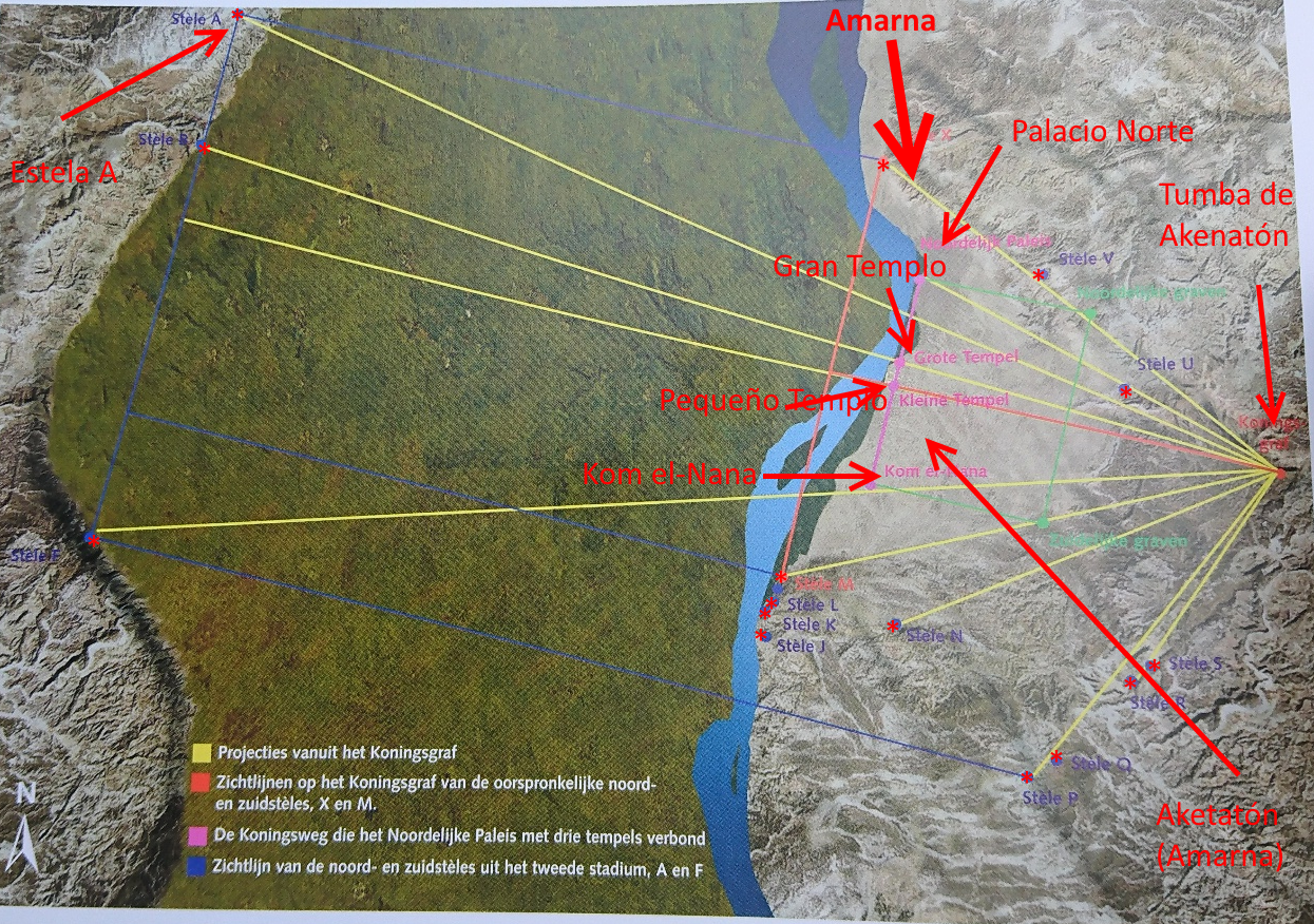
En realidad la mayoría de las estelas eran visibles desde la tumba de Akenaton en el Wadi Real (Wadi es barranco – cauce de un río seco que únicamente contiene agua durante tormentas), así también la estela A, como se ve en la figura siguiente:
 |
|
| El paisaje sagrada de Aketatón con las estelas fronterizas (asteriscos rojos). La tumba de Akenatón se encuentra a la derecha centro, y nuestra estela fronteriza a la izquierda arriba. Las líneas amarillas son ‘lineas de vista’. Imagen: Freed, R.E., Y.J. Markowitz, and S.H. D’Auria. Farao’s van de Zon. Achnaton, Nefertiti, Toetanchamon [Pharaohs of the Sun. Akhenaten, Nefertiti, Tutankhamen]. Rijksmuseum van Oudheden. Leiden: Ludion, 2000. |
-

Detalle del panel con Akenaton, Nefertiti y sus dos hijas mayores rezando a Atón, con ofrendas de pan y aceites 
La estela A con sus estatuas, entre otros Nefertiti, el panel de interés se encuentra en la parte derecha arriba La estela fronteriza fue por primera vez descrita por un europeo (que sepamos!) en 1714, por el jesuita Claude Sicard, y la describe así interpretando la escena como un sacrificio:
«« C’est un sacrifice offert au soleil. Il est représenté en demi-relief sur une grande roche, dont la solidité a bien pu défendre ce demi-relief contre les injures du temps ; mais elle n’a pu résister au fer, dont les Arabes se sont servis pour détruire ce que l’on voit de tronqué dans la figure de ce sacrifice. Je l’ai dessiné tel que je l’ai vu. La roche dont j’ai parlé fait partie d’un grand roc, qui est au milieu d’une montagne. Il a fallu bien du temps et un pénible travail pour venir à bout de faire dans ce roc une ouverture de cinq ou six pieds de profondeur, sur une cinquantaine de largeur et de hauteur. C’est dans cette vaste niche creusée dans le roc que toutes les figures qui accompagnent ce sacrifice du soleil sont renfermées. On voit d’abord un soleil environné d’une infinité de rayons de quinze ou vingt pieds de diamètre. Deux prêtres de hauteur naturelle, couverts de longs bonnets pointus, tendent les mains vers cet objet de leurs adorations. L’extrémité de leurs doigts touche l’extrémité des rayons du soleil. Deux petits garçons, ayant la tête couverte comme les prêtres, sont à leur côté et leur présentent chacun deux grands gobelets pleins de liqueur. Au-dessus du soleil, il y a trois agneaux égorgés et étendus sur trois bûchers, composés chacun de dix pièces de bois. Au bas du bûcher sont sept cruches avec des anses. De l’autre côté du soleil, opposé au côté des deux sacrificateurs, il y a deux femmes et deux filles en plein relief, attachées seulement par les pieds à la roche, et un peu par le dos. On y voit les marques des coups de marteau qui les ont décapitées. Derrière les deux petits garçons, il y a une espèce de cadre chargé de plusieurs traits hiéroglyphiques. Il y en a d’autres plus grands qui sont sculptés dans les autres parties de la niche. Je cherchai de tous côtés quelque inscription, ou autre chose, qui pût me donner l’intelligence de toutes ces différentes figures, et de l’usage qu’on en a voulu faire, ou qui pût du moins m’apprendre l’année où cet ouvrage a été fait, et le nom de son auteur. Je n’ai pu rien découvrir ; ainsi je laisse aux savants, curieux des antiquités, à deviner ce qui m’est demeuré inconnu. Après avoir employé autant de temps qu’il en falloit pour dessiner fidèlement la représentation de ce sacrifice, qu’on dit être un sacrifice offert au soleil, j’allai passer la nuit à Mellawi.
Citado en Laboury, Dimitri. Akhénaton (Les grands pharaons) (French Edition) (Kindle Locations 208-216). Pygmalion. Kindle Edition.
El resto del día es libre estancia en Hermopolis…
Fuentes de información:
https://de.wikivoyage.org/wiki/T%C5%ABna_el-Gebel
https://de.wikivoyage.org/wiki/Aschm%C5%ABnein
https://es.wikipedia.org/wiki/Tuna_el-Yebel
https://en.wikipedia.org/wiki/Hermopolisy los libros citados.
PD1.

Fragmentos a-f son de Tuna el-Jebel – se han indicado con flechas los cartuchos con Nefereferuaten Nefertiti
Karl Lepsius (Denkmäler aus Aegypten und Aethiopien 1842-1845) TAFELWERKE BAND VI, seite 91
Detalle de la tabla anterior: Ya representado en «Informe sobre los textos en latín de los grafitos de carácter excepcional de Iruña-Veleia» de Idoia Filloy 
Cartucho real (https://en.wikipedia.org/wiki/Nefertiti) El lugar del yacimiento de Tuna el-Jebel aparece aparentemente en autores clásicos, lo que significa que tenemos la imagen de Nefertiti y Akenaton (incluidos sus cartuchos), cerca de un lugar de culto muy importante. La siguiente estela fronteriza estaba a solo 3 kms de la estela A. Hasta ahora no hemos encontrado esta relación en autores recientes, pero lo encontramos en un libro de François Champollion (18014) y uno de John Gardner Wilkinson (1843) Champolleon no parece haber visitado Tuna el Gebel durante su visita a Egipto, pero nos comenta lo siguiente.
Ibiù. — Nhip. C’est auprès d’Hermopolis et au nord de Cusœ y que les anciens placent un lieu peu considérable dont le nom fut Ibeum. Il est particulièrement cité dans l’Itinéraire d’Antonin , sous le nom d’Ibiù. Cet auteur l’indique à vingt – quatre milles au nord de la grande ville de Thoth ou Hermopolis – Magna. Selon Hérodote , c’était dans cette dernière ville que les Egyptiens transportaient ( 2 ) les Ibis qui mouraient dans les diverses parties de l’Égypte , et leurs cadavres embaumés étaient déposés dans un lieu destiné à les recevoir. Mais ce rapport d’Hé rodote ne semble pas rigoureusement exact , et il ne doit peut-être s’entendre que des Ibis nourris dans les temples , puisque on trouve dans les catacombes des environs de Memphis un nombre pro digieux de momies de cet oiseau. Une personne dont´le témoignage n’est point suspect , nous a certifié avoir vu dans un de ces souterrains taillés dans le roc, une incroyable quantité de ces oiseaux embaumés,, et renfermés dans des vases de terre placés horizon talement l’un sur l’autre , à une hauteur uniforme , contre les parois du souterrain. Après avoir connu l’espace qu’occupait un nombre donné de ces momies, et avoir mesuré l’étendue du souterrain , elle s’assura qu’il en contenait plusieurs millions. Ce fait sera reproduit ailleurs dans tous ses détails, et il semble prouver ce que nous avons avancé, qu’Hérodote n’a pu parler que des Ibis sacrés, lorsqu’il a dit qu’on les transportait à Hermopolis. M. Larcher pense que ce n’était pas précisément à Hermopolis-Magna qu’on enterrait les Ibis , et qu’ils n’étaient transférés dans cette ville qu’à cause du lieu voisin appelé Ibeum, où on les déposait ( 2 ). Mais comme dans l’Itinéraire d’Antonin , Ibiù est placé à vingts quatre milles au nord d’Hermopolis , il ne paraît pas naturel qu’on envoyât d’abord les Ibis à Hermopolis , pour les faire rétrograder ensuite vers le septentrion. Pour que cet inconvénient n’existât point, il faudrait nécessairement que le lieu appelé Ibeum se trouvât au midi d’Hermopolis et à très -peu de distance de cette ville. Ibeum tirait son nom de l’Ibis, qui, en égyptien, était appelé , Hip , d’où les Grecs ont fait en y ajoutant la désinence grecque is. Le nom égyptien de Ibeum des Latins devait être réguliè rement XXXX , Manhip, ou simplement XXXX, Nhîb , lieu des Ibis. On le retrouve dans Étienne de Byzance et dans Suidas , sous la forme grecque de XXXX , que nous croyons être le nom égyptiens d’Ibeum qu’ils n’ont point mentionné sous cette dernière forme. En retranchant de ce mot la ter minaison grecque iç , on trouve XXX , qui est exac tement leXXXX égyptien. Il n’en diffère que par l’absence de H , hori, que les Grecs ne pouvaient pas exprimer, parce qu’il manquait à leur alphabet. C’est ainsi , par exemple , qu’ils ont écritXXX égyptien XXXX, qui signifie cœur (2).Champollion, Jean François. L’Egypte sous les Pharaons ou recherches sur la géographique, la religion, la langue, les écritures et l’histoire de l’Egypte avant l’invasion de Cambyse. Chez de Bure frères, 1814, p. 295-297.

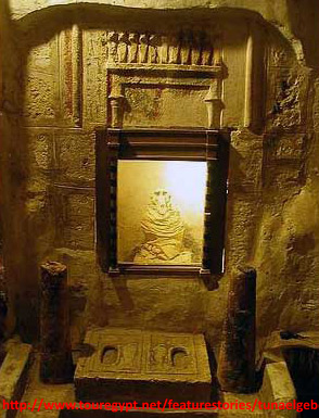
Corredores de las catacumbas
http://www.touregypt.net/featurestories/tunaelgebel.htm
Babuino momificado dentro de las catacumbas
http://www.touregypt.net/featurestories/tunaelgebel.htm
Nichos con los sarcófagos de ibis momificados
http://www.touregypt.net/featurestories/tunaelgebel.htm
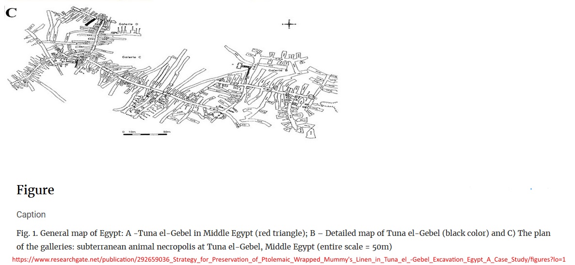
Laberinto de las catacumbas de Ibeum (escala 50 metros) John Wilinson Gardner efectivamente visita el Tuna el Gabel y comenta lo siguiente:
The tombs of the ancient city lie at the base of the Libyan
hills to the westward, where numerous ibis mummies have been
buried, many of wliich are found deposited in small cases, and
perfectly preserved. The cynocephalus ape (bavuino) is also met with,
embalmed and buried in the same consecrated spot. It is
here that Ibeum, or Nhip  probably stood; for it is
evident that the position given it in the Itinerary of Anto-
ninus is incorrect ; and Ibeum, the burying-place of the
sacred birds of Hermopolis, could not have been 24 miles
distant, to the north of that city. Not far from these tombs
is a curious sculptured stela, on the nummulite rock of Gebel
Toona, representing the king Atin-re-Bakhan with his queen,
worshipping the Sun, which darts forth rays terminating in
human hands ; a subject similar to those in the grottoes of
Tel el Amarna, which I shall mention presently. They are
accompanied by two of their daughters, holding sistra.
Below the figures are between twenty and thirty lines of
hieroglyphics much defaced; and near it are two headless
statues supporting a sort of tablet, with three daughters of
the king on the side in intaglio. Beyond are two other
statues, and at the side of this, as of the other group, are two
small mutilated figures.
Wilkinson, John Gardner. Modern Egypt and Thebes: Being a Description of Egypt; Including the Information Required for Travellers in that County. Vol. 1. J. Murray, 1843.Ambos autores afirman la relación de Tuna al Gebel y un necropolis gigante de ibis, sobre lo cual Herodoto, historiador griego del siglo V a. de C. ya nos informa
Herodoto cita en su ‘Historia’ el necropolis de ibis (ibiotaphon) – catacumbas que se encuentran a 1 km de la estela A con Neferetete y Akenaton y sus cartuchos, y a 5 kms del antiguo Hermopolis, ciudad de Hermes:
libro II, cap 67 sect. 1Dead cats are taken away to sacred buildings in the town of Bubastis, where they are embalmed and buried; female dogs are buried by the townsfolk in their own towns in sacred coffins; and the like is done with mongooses. Shrew mice and hawks are taken away to Buto, ibises to the city of Hermes.
Traducido es algo como:
Los gatos muertos son llevados a los edificios sagrados en la ciudad de Bubastis, donde son embalsamados y enterrados; Las perras femeninas son enterradas por los habitantes de la ciudad en sus propios pueblos en ataúdes sagrados; Y lo mismo se hace con mangostas. Musarañas y halcones se llevan a Buto, ibises a la ciudad de Hermes.
Originalmente:
ἀπάγονται δὲ οἱ αἰέλουροι ἀποφανόντες ἐς ἱρὰς στέγας, ἔνθα θάπτονται ταριχευθέντες, ἐν Βουβάστιπόλι: τὰς δὲ κύνας ἐν τῇ ἑωυτῶν ἕκαστοι πόλι θάπτουσι ἐν ἱρῇσι θήκῃσι. ὣς δὲ αὕτως τῇσι κυσὶ οἱ ἰχνευταὶ θάπτονται. τὰς δὲ μυγαλᾶς καὶ τοὺς ἴρηκας ἀπάγουσι ἐς Βουτοῦν πόλιν, τὰς δὲ ἴβις ἐς Ἑρμέω πόλιν.Además encontramos en el Itinerario Antonini una referencia a un lugar Ibiù cerca de Hermopolis que por su raíz Ibi puede relacionar con Ibeum y el necropolis de los ibis a los que Herodoto hace referencia en la ciudad de Hermes.
 Itinerarium provinciarum omnium Antonini Augusti cum Fragmento eiusdem necnon indici haud quaque aspernando
Antoninus Pius1512 | Editor: Stephanus

Digital atlas of the Roman empire (http://dare.ht.lu.se/)


Según lo afirmado en una información túristica (http://www.touregypt.net/featurestories/tunaelgebel.htm) la zona del necropolis era también un muy importante centrum de produción de fayenza, que se ha encontrado extensamente en el necropolis.
A modo de conclusión: Tenemos en Tuna el-Jebel un claro ejemplo donde iconografía bien identificable y el cartucho de Nefertiti estaba muy cerca de un lugar muy transitada durante gran parte de la antigüedad y que es además de alguna relevancia religiosa, que forma un posible mecanismo de transmisión del nombre de la reina que llamamos hoy en día Nefertiti.
PD2.
Añado también unos detalles sobre el descubrimiento y el contenido de estela fronteriza A:
Not many westerners ventured south of Cairo before the nineteenth century of our era, and the banditry endemic to Middle Egypt discouraged most foreigners from lingering there. Thus it was not until the early 1700’s that Europeans were allowed a glimpse of Akhet-Aten and its antiquities. Stela A, by virtue of its proximity to modern settlements no less than by its relatively good preservation, is the most conspicuous of Akhenaten’s monuments in the region around El-Amarna, and western travellers began noticing it in the early years of the eighteenth century.5 The first European to call attention to it was the Jesuit Claude Sicard, who published a description of the site, along with a sketch, shortly after visiting it in 1714.6 Other travellers passed through the area later on, notably Richard Pococke7 and E. Jomard (the latter with the Napoleonic expedition at the end of the eighteenth century),8 but the stela itself was noted by only one other visitor, in 1777.9 By the earlier part of the nineteenth century, when more westerners were able to travel and even reside in Egypt, the monument of Tuna el-Gebel was one of the recognized sights on any visitor’s itinerary through Middle Egypt. Joseph Bonomi saw it early in 1825,10 and Robert Hay made a number of drawings at the site in 1827,11 perhaps having learned of it from John Gardner Wilkinson.12
Murnane. Boundary Stelae Of Akhentaten (Studies in Egyptology) 1993/2011 (Kindle Locations 235-244). Taylor and Francis. Kindle Edition.
The tablet, which contains the Later Proclamation, “repetition of the oath” and the Colophon, stands on the right side of the niche. In the lunette are the king, queen, Meritaten and Meketaten standing on the right before the offering tables directly beneath the disk at the center, balanced by eight vertical columns of text on the left, with the rest of the inscription in 25 horizontal lines below. The text runs from left to right. Davies believed that it had been systematically battered, and large areas of the surface do appear to be worn down in a fashion that is consistent with hammering. The most clearly intentional damage, however, is to the king’s names and even here it is not comprehensive, so perhaps the more general hammering was done later, as casual vandalism rather than by Akhenaten’s enemies. Some of the damage that defeated early copyists at the middle of the tablet seems to be due, rather, to the friable nature of the fossil-laden stone, which has worn away along the edges of the signs. Two statue groups, each consisting of the king, queen and the two eldest princesses, stand to the left of the tablet. Three princesses’ figures were carved onto the south side of the altar held by the king and queen in the left-hand statue group, as already recorded by Davies.5 (The problem of when the third princess was added at this and other sites will be discussed in Chapter Five.) The statue groups stand on bases that are considerably higher than is customary for these sculptures at other sites (for further discussion, see Chapter Four). The likeliest explanation for this anomaly is that the tablet, originally designed to contain only the Later Proclamation and the “repetition of the oath”, had to be enlarged to accommodate the Colophon; and since its size could only be increased downward, the entire floor of the platform was lowered, leaving the statues at their original level high above the new floor. Apart from the height of the statue bases, there is some evidence for this assumption in the text. At the middle of the tablet, for example, the standard size of hieroglyphic groups diminishes and the left margin is even shifted slightly further left (at line 14), as if the sculptors were trying to make the most of the available surface. Greater expansiveness in the layout of the text returns, however, near the bottom, where the workmen could employ the additional space provided by the lowering of the floor. The heads of all the statues are missing –– and since this condition was noted as early as 1714, when Sicard made his drawing of the site, it is likely that this mutilation had already occurred in antiquity. In all other respects, the site seems to have suffered little damage in modern times –– perhaps owing to its fame as a local “sight.” At some point in its more recent history (probably within the last century) the niche was protected by a gate, the emplacement for which we found on clearing the sand from the floor. Side-walls and a roof have been built around the niche more recently, but otherwise the monument is open and unencumbered today. This is the only one of the boundary stelae that is visited by tourists on a regular basis.
Murnane. Boundary Stelae Of Akhentaten 1993/2011 (Studies in Egyptology) (Kindle Locations 1415-1430). Taylor and Francis. Kindle Edition.